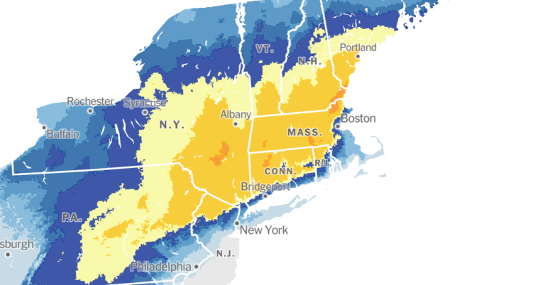
A powerful winter storm will drop the first significant snow of the season across parts of the Northeast this weekend, bringing up to a foot of snow in some places across the North Central Atlantic and New England.
The storm is expected to move northeast to Cape Cod, Massachusetts, and then “will rapidly deepen as it moves over the western Atlantic by Sunday evening,” according to the Weather Prediction Center.
“The combination of heavy snow rates exceeding one inch per hour and gusty winds will lead to snow-covered roads and limited visibility, creating dangerous travel,” meteorologists said Saturday afternoon. “In some areas, especially southern New England, the snow may be heavy and wet, which could cause isolated power outages and tree damage.”
There is a possibility that cities, including New York — where the Division of Emergency Management on Friday warned residents to prepare for “snow, rain, high winds and minor coastal flooding” — could receive an inch of accumulating snow or more through Sunday. It's been nearly 700 days since Central Park received the last inch of snow in a single day.
Meteorologists said Saturday that up to a foot of snow could fall in northeastern New Jersey, the Hudson Valley north of New York City and southwestern Connecticut.
This is a good time to expect circumstances to change.
-
Freezing rain fell across the Appalachian region of western North Carolina, western Virginia and eastern West Virginia, but it was is expected To be cleared by Saturday evening. Forecasters said they were “expecting cold, miserable rain” across the region.
-
Rainfall, which began spreading across the Northeast Saturday afternoon, will continue into Sunday.
-
Heavier snowfall of 8 to 12 inches is likely farther north and west of New York City, from northeastern Pennsylvania to southern Maine. Pockets of larger quantities, more than a foot, are possible.
-
A rain-to-snow transition line will likely be established right along the Interstate 95 corridor, with a sharp change from heavy snowfall west and north of the interstate to a wintry mix of snow, sleet and rain along the coast.
-
The combination of heavy, wet snow and gusty winds in Connecticut, Massachusetts and Rhode Island could lead to power outages and tree damage.
On Saturday morning, forecasters said the latest trend in their computer models pointed to drier and sunnier weather on Monday, with another storm possible arriving on Tuesday.
This storm will be followed by a larger and stronger storm.
The next storm system is expected to be stronger and warmer, and its effects will be more widespread. Meteorologists said the hurricane will intensify into a dynamic storm over the Great Plains and affect the East Coast from early to mid-week.
Heavy rainfall from Texas to the Northeast will be a significant factor in that storm.
This means any snow from Sunday could be washed away by heavy rain by Wednesday, increasing the chances of flooding in places hit by both.
Forecasters predicted great River flooding Heavy rain fell Tuesday in large parts of Pennsylvania, Washington, D.C., and Maryland.
On the northwest side of this storm system, significant winter storm conditions are likely from Kansas to the western Great Lakes, including possible blizzard conditions.
On the southeast side, across the south, severe storms are likely, with tornadoes possible.
Forecasters warned people to prepare for the second storm system because the region will only have about 48 hours of relative calm before some places begin to experience the effects of this upcoming storm.
Emily North And Amy Ortiz Contributed to reports.

