As pressure – a fair-weather cell – rises from Canada's peaks over New England, the Tuesday morning breeze will calm down during the day as cold air remains entrenched in the region for the time being.
The high pressure center is usually filled with dry air, and Tuesday is no exception, as the dry air not only ensures an abundance of sunshine, but also dehydrates the body – a bit of hidden dehydration since the temperature is not so warm that the body does not feel dehydrated. You wouldn't know it, but the dry air means that moisturizing, lip balm and skin moisturizer will all come in handy to mitigate the effects on the body.
A large ocean storm developing Tuesday night and Wednesday will remain hundreds of miles southeast of New England, but it should add some weak, high-altitude clouds to the sky that will dim the sun in eastern New England, but certainly shouldn't drop any rain. In very dry air.
While winds will remain light across most of New England, Wednesday and Thursday should see increased winds over Vermont, where the Champlain Valley will find daytime gusts up to 30 mph on both days, as western New England lies between the valley Leaving slowly. A high pressure cell and a weak storm center above the Ontario-Quebec line in Canada.
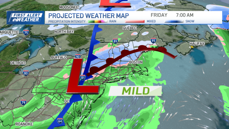
Eventually, a new, stronger storm center will develop out of the Ohio Valley on Thursday and move directly over New England on Friday.
At first, there will likely be enough cold air remaining to push snow into north-central and western Massachusetts northward in up to 2 inches of layer, before moderate air brings an increasing southerly breeze with the incoming storm and changes the precipitation. Showers during the day Friday with temperatures rising well into the 40s and close to 50 degrees for some.
Soon after, a cold front associated with the center of the storm will pass through New England by later Friday, ending the push of mild air northward and delivering another shot of cold, dry air for a mild winter weekend.
However, this week is the week we historically see, on average, the daily high temperature in Boston exceed 40 degrees, and there is a turning point of sorts this year — once the weekend is over, the jet stream pattern reshapes in a way that will… Sending exceptional warmth to New England, making next week more similar to the first week of April.
The midsection of the country is getting warmer this week and into the weekend, and once the fast winds of the jet stream aloft begin to rise northward over New England by the end of next weekend, that opens the door to temperatures in the 50s through most of next week. With a high probability of rain.

