Andres KOAT 7 weather forecast for February 17, 2024
Cool temperatures across the state coming from a breeze and some drizzle
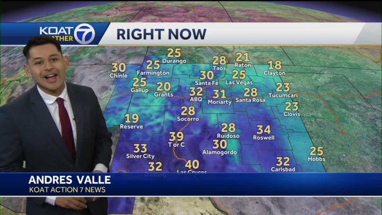
now. 624 This Saturday morning, we wake up to a very cold start. You may notice that today's temperatures will be a little cooler than yesterday's. Yesterday was quite comfortable. We were in the upper 50s. Some areas saw the 60s, but it was gripped by disturbance that actually affected the eastern half of the state. So we're talking temperatures in the 20s for areas of northeastern New Mexico. But we're in our teens now for Clayton. good morning to you. 18 degrees 32 degrees now in Albuquerque. Good morning to our friends at Moriarty. You're at 31 degrees With that said, you can see where a lot of that cold air is now directly east of the central mountain range. So we're talking anywhere from 10 to 15 degrees plus temperatures cooler at this hour than we were yesterday. The southwestern half of the state is actually a couple of degrees warmer, of course, and the cold air will hopefully pass through the passes of the Central Mountain Range. Now we're dealing with some gusty winds as well, across the eastern half of the state, clocking in at around 10 to 15 mph. Now we're at 20 mph, even though in Tucumcari. In addition, it is allowed to raise some humidity in the atmosphere. So we're tracking a little bit of freezing drizzle across the eastern half of the state. Some areas are witnessing some light flurries across northern New Mexico. This includes Raton, but for now, there is a Freezing Fog Advisory in effect until 11:00 this morning. So we are dealing with low visibility and icy and slippery roads in a lot of areas. As for the rest of the day, we will start to see the start of rain later in the afternoon. However, we will continue to maintain this cloud cover over areas of eastern New Mexico and into the northern half of the state. You may see a little bit of some fluctuations. Of course, Union County and Colfax are under a winter weather advisory, at least for the rest of the day. But where. It might be talking about an inch of accumulated snow or ice, so nothing too crazy, but something to keep in mind if you're traveling along Interstate 25. heading toward southern Colorado. As for 5:00, notice that cloud cover begins to form over the high terrain in western New Mexico. We are looking for highs in the lower 50s. For Albuquerque, we're in the 50s for Las Cruces. In terms of accumulating snow amounts, this particular model wants to bring maybe 3/10 of an inch for TAOS, and maybe 10 of an inch for Raton. So, not impressive numbers with the freezing drizzle or light snowfall we might see this morning, but something we can add to our yearly collection. We're also keeping a close eye on Wednesday's forecast, as this could be the next weather impact day. As of now, models are keeping wind gusts below impact parameters, but other areas in New Mexico will see some very strong winds. We're talking about 60 mph in peak wind gusts expected right now. According to this last model, Wednesday comes in the afternoon. So it will be windy on Wednesday. Just giving you a heads up for now. But this weekend we have to get over that first. For the most part, I think we'll be under mostly sunny skies until the latter half of the day, when we start to see those clouds start to accumulate in northwest New Mexico, so more cloud cover is expected on Sunday. We'll see more sunshine for the Chiefs' day toward southwestern New Mexico. We're in the 60s for Lordsburg, Deming, and Las Cruces, at least for Silver City. We will see mainly sunny skies today and tomorrow. Slight warm trend. Check it out in the mid-1960s. By Tuesday, it's getting windy for you guys. On Wednesday this allows temperatures to drop with the next disturbance there towards southeastern New Mexico. We are only in the 30s for areas like Fort Sumner, Roswell, and Hobbs, the lower 40s and upper 30s for the Sacramento Mountains, and the mid 30s for Roswell. Today we will keep this cloud cover in place. Some light drizzle can also be seen. And check out this cozy '80s trend. Come Tuesday, it will be some of the warmest temperatures we've seen this year. Even now, as these gusty winds arrive and these disturbances pass, we'll see those temperatures drop into the upper 70s and upper 60s. Heading into the second half of the work week, heading into Las Vegas, we have freezing drizzle this morning with a flurry of snow mixed in there. So, we will only get to 30°C today. Then we should get into the 50s tomorrow. Gradual warming trend in the 1960s. Stormy winds on Wednesday. North central New Mexico. We could see double flurries near the Red River or even in Taos today. Overall highs are in the 40s in the northern mountain areas and in Santa Fe as well. Upper 40s. And then we have this warm trend into the upper 50s before we see temperatures drop. After all the turmoil in the metro here, we'll be mostly sunny today with double clouds becoming more and more apparent
Andres KOAT 7 weather forecast for February 17, 2024
Cool temperatures across the state coming from a breeze and some drizzle


