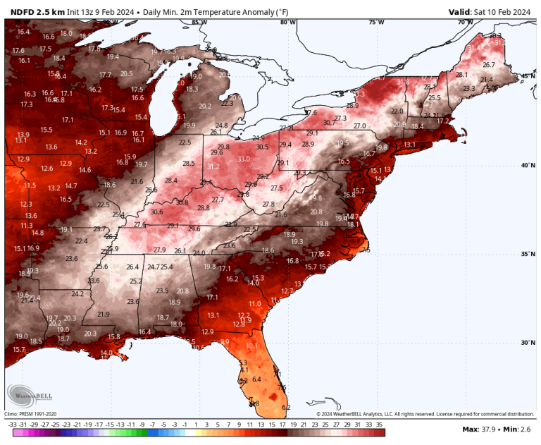
Since the beginning of February, temperatures in the country's northern tier have risen to nearly 40 degrees above normal at times. Many places that are normally buried in snow have bare ground and temperatures more typical of spring.
Minneapolis, where there is no snow, spent most of this week with highs in the 50s, and set records on Tuesday and Thursday. The average high in early February is in the mid 20s.
“I've seen reports of tick sightings, tulips appearing, and even some (very early) baseball practices. What month is it again?,” meteorologist Paul Douglas wrote in the weather column for the Minnesota Star Tribune.
This warm spell is reminiscent of the weather in December, when many of the same regions experienced unusual warmth. There was no snow cover in parts of northern Minnesota on Christmas for the first time. During the month, 31,230 warm weather records were set in the United States, compared to only 53 cold weather records.
It is known that the El Niño climate phenomenon tends towards mild winters in the northern United States, and this year's pattern is the fifth strongest pattern ever recorded.
In addition to the El Niño phenomenon, human-induced climate change resulting from the burning of fossil fuels increases the likelihood of such exceptional warmth. The European Union's Copernicus Climate Change Service announced Thursday that the planet recorded its warmest January on record and that the past 12 months have averaged more than 1.5 degrees Celsius above pre-industrial levels for the first time.
However, there are signs that this warm wave will end from west to east over the weekend and into early next week.
How warmth evolved and records were set
Record warmth began the week extending from the Desert Southwest into the upper Midwest and then slowly progressed eastward.
As the weather wave responsible for California's deluge earlier this week shifted eastward, it helped pull spring moisture north toward Canada. On Thursday, Wisconsin witnessed its first tornado in February, with high temperatures in parts of the state exceeding previous records by about 10 degrees.
Ahead of the severe storms, record temperatures engulfed much of the Midwest. Places with record calendar-day highs on Thursday included Cedar Rapids, Iowa, at 66 degrees; Rockford, Illinois at 59 degrees; La Crosse, Wisconsin, at 59 degrees.
Through Thursday, several weather monitoring sites reported multiple record highs this month, including:
- 5 Waterloo, Iowa
- 4 in Sault Ste. Marie, Michigan.
- 3 in Rockford, Illinois
- 2 in Green Bay, Wisconsin, and others
Multiple cities also recorded record low temperatures, including North Platte, Nebraska; Sioux Falls, SD; and Huron, S.D. — which saw five this month.
So far, February is the warmest or second-warmest February on record for most of the Midwest and Great Lakes, according to weather service data. Temperatures in most parts of Minnesota are at least 20 degrees above normal for the month. The average temperature in Fargo, ND, was 27 degrees above normal as of Thursday.
Because of the vastness of the bare ground in locations normally covered with snow, only 27.6 percent of the contiguous United States was covered by snow as of Friday morning, one of the three lowest percentages recorded so far.
Record warmth spreading eastward
Temperatures rising into the 50s and 60s are expected to drop more records in the Great Lakes and Northeast on Friday and in the mid-Atlantic and Northeast on Saturday. Dozens of record low temperatures are expected in the same areas over the weekend.
Record highs at risk on Friday, about 20 to 30 degrees above normal, include:
- Detroit: Expected temperature: 63 degrees; The record is 56 degrees in 2001.
- Fort Wayne, Indiana: Expected temperature: 61 degrees; The record is 61 degrees in 2001.
- Syracuse, New York: Expected temperature: 59 degrees; The record is 59 degrees in 1902.
On Saturday, the following record highs – about 15 to 25 degrees above normal – are possible:
- Washington Dulles International Airport: Expected temperature: 63 degrees; The record is 63 degrees in 2001.
- Hartford: Expected temperature: 56 degrees; The record is 55 degrees in 1909.
- Albany, New York: Expected temperature: 55 degrees; The record is 53 degrees in 1955.
- Burlington, Vermont: Expected temperature: 52 degrees; The record is 46 degrees in 2001.
Toledo, Cleveland, Pittsburgh, Buffalo, Washington and Roanoke could all record warm lows over the weekend as morning temperatures are expected to be 30 to 40 degrees above normal over a large area.
As a cold front sweeps through the Midwest and sweeps across the East Coast early next week, the widespread unseasonable warmth will end.
While the weather pattern will become cooler, there is no tangible sign of a severe cold spell. An active jet stream across the southern United States could mean cold, stormy weather from California across the South and toward the East Coast, but extreme cold may continue to evade the northern-central states.
Jason Samino contributed to this report.

