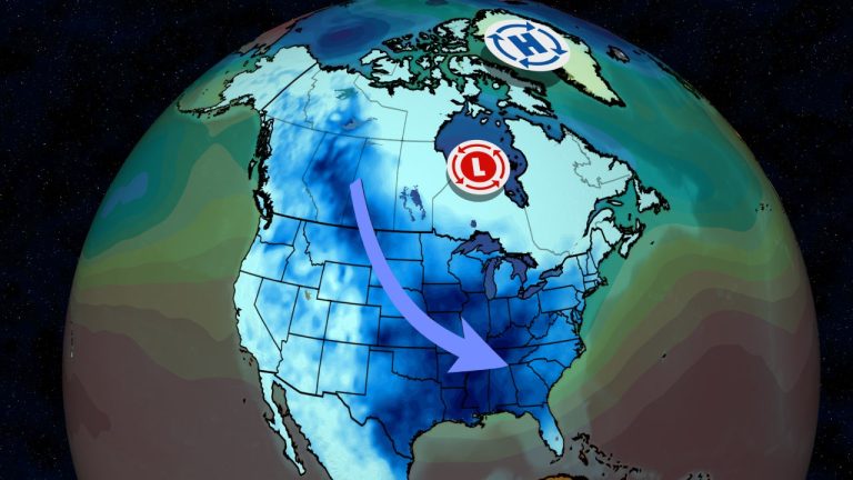

- A wave of cold, arctic air is pouring into the United States
- It will push through the south by the end of this week, and could drop temperatures below freezing for several days in a row.
- Many daily cold records will be at risk.
- Dangerously cold winds are also expected, especially in the northern Plains and Rocky Mountains.
- This generally cooler pattern could last until the last full week of January or longer.
An Arctic cold outbreak is expected to bring cold air to large parts of the country, including the Deep South, over the next week. Daily records for mid-January could be broken from Washington state to the Gulf Coast.
When will it happen: The first gust of cold air rushes southward into the plains. The temperature at a reporting station near Rainsford, Montana, dropped to minus 43 degrees on Friday morning. The temperature in Watson Lake in British Columbia, Canada, dropped to 57 degrees below zero.
Wind chills as low as minus 68 degrees were measured Friday morning at Whitefish Ski Resort in Montana, and The wind was recorded at 72 degrees below zero In the Northwest Territories of Canada.
(Current map trackers: Temperatures | Wind chill)
A stronger cold blast will push south, from the northwest across the Southern Plains and Midwest this weekend, before making its way toward the southeast early next week, and finally the East Coast on Wednesday.
(Enhance your forecasts with our hour-by-hour breakdown for the next eight days – available only on our website.) Premium Pro experience.)


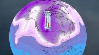
This animation shows how much below average low temperatures are expected to be each day through next Friday. The brighter pink lines indicate where low temperatures are expected to be below average for this time of year.
How cold will it get: During the coldest days of the outbreak…
- Lows will occur in the 20s, and perhaps a few teens, along the northern Gulf Coast, from eastern Texas to northern Florida.
- Teens, perhaps a few low numbers, are expected in the Deep South.
- Low temperatures could reach below zero as far south as parts of the Texas Panhandle, Oklahoma and northern Arkansas.
- Temperatures could drop to 20 degrees below zero as far south as Iowa and Nebraska.
- Low temperatures in some areas of Montana will reach 40 degrees below zero.
Daily records — the coldest on a calendar day — are possible from Washington to Wyoming this weekend, and then in parts of the Plains and Deep South, Monday through Wednesday.
Among the notables, Chicago's O'Hare Airport could drop to -10 for the first time since a cold outbreak in January 2019, and may fail to rise above zero during the day Monday and/or Tuesday. Oklahoma City may drop below zero for the first time since a historic cold outbreak in February 2021. However, we do not expect this outbreak to match the severity of the outbreak in January 2019 or February 2021.
(Forecast details: The highest and lowest levels in the United States in 10 days)
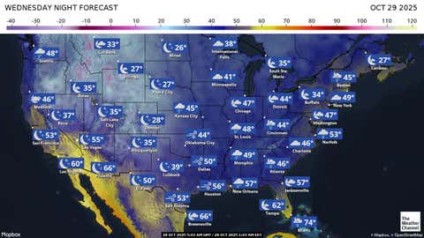

Saturday night forecast
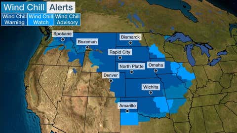
Danger of cold winds: Strong winds will also accompany the Arctic air. These winds will combine with the cold to produce dangerous wind chills in the Rockies, Plains, and Midwest.
Some wind chills in the northern Plains can drop to 40 degrees below zero, and even 50 degrees below zero, at times, which can lead to frostbite on any exposed skin in as little as 10 minutes.

How long will it last: In many of these areas, the coolest air will be either during this weekend or during the first half of MLK week. Parts of the South, including Oklahoma City, Dallas and Nashville, could see several days in a row with daytime temperatures rising below freezing.
However, another blast of cold air is now expected in many of these same areas late next week that will continue at least through the weekend of January 20-21.
Furthermore, some cold air is possible, especially in the northern United States, during the week of January 22.
Why is it so cold: There are several reasons for this strong cold outbreak.
First, a blocking of high pressure near Greenland and the Canadian Arctic pushes cold air out of Canada deep into the United States, a common pattern for winter outbreaks.
This cold air will be kept chilled by large, widespread snowpacks over the United States thanks to the recent blockade of winter storms.
All this usually happens during the coldest times of winter.
This is a stunning reversal of the pattern that led to America's record warmest December in 129 years and the lowest Christmas snow cover in 20 years.


More at Weather.COM
– How to prevent frozen pipes in your home
– Tips for staying warm when the power goes out
– How to protect yourself from hypothermia
– Potential weather impacts on NFL Wild Card weekend
Jonathan Erdmann is a senior meteorologist at Weather.com and has been covering national and international weather since 1996. His lifelong love of meteorology began with a close encounter with a tornado as a child in Wisconsin. He studied physics at the University of Wisconsin-Madison, then completed a master's degree working with dual polarization radar and lightning data at Colorado State University. Extreme and strange weather are his favorite subjects. Contact him on X (formerly Twitter), Threads, Facebook And the sky is blue.
The Weather Company's primary journalistic mission is to report on breaking weather news, the environment, and the importance of science in our lives. This story does not necessarily represent the position of our parent company, IBM.

