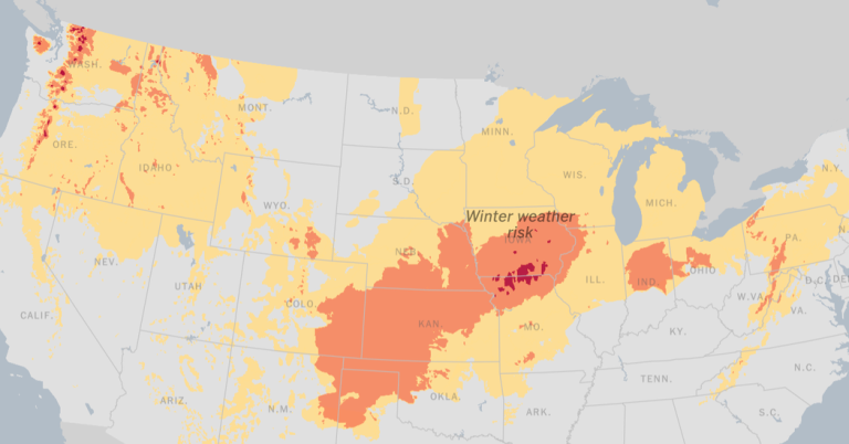
A series of powerful storms continues to wreak havoc across the United States on Tuesday, bringing major weather of almost all types to large portions of the Pacific Northwest, Plains, Midwest, South and East Coast.
-
Heavy rain will hit the New York area from late Tuesday into Wednesday, with flooding and damaging winds possible.
-
Severe weather and flooding are expected from the Florida Panhandle to southern Maine.
-
Blizzard conditions will continue in the High Plains across the upper Midwest with more possible by the end of the week.
-
A strong cold front will continue to impact the Pacific Northwest, bringing several feet of heavy snow and blizzards across the Cascades. Heavy snow will also continue to blanket the northern Rockies.
Rain, rain and more rain in the east.
The eastern third of the United States will see widespread hazardous weather on Tuesday, especially in the form of heavy rain capable of causing flooding from the Florida Panhandle all the way north into southern Maine, forecasters said.
A moderate heavy rain warning was issued early Tuesday into the evening from northern Virginia into southern New England, where up to three inches of rain could cover already very saturated, and in some places snow-covered, ground. Strong winds of up to 50 mph are also a concern Tuesday near the coast and higher elevation areas where wind speeds are likely to exceed 50 mph.
Meteorologists warned that in places where strong winds blow, the chances of power outages increase.
Severe weather that could produce tornadoes is also expected to hit northern Florida as far as the Carolinas.
Across the New York area, up to four inches of rain and strong winds are expected late Tuesday into early Wednesday, increasing the risk of major river flooding around New Jersey, the lower Hudson Valley and parts of Connecticut. A flood watch is scheduled to be in effect across the area from the evening until midday Wednesday.
The Plains and upper Midwest are seeing dangerous blizzard conditions.
Bands of heavy snow with snowfall rates of about 1 inch per hour will settle over parts of the upper Midwest, making travel risky on Tuesday.
Snow will still be a problem in parts of the plains. Parts of the area will see blizzard conditions with up to six inches of snow combined with winds of up to 40 mph and gusts of up to 60 mph. Valleys in the area could see five inches of snow, while mountaintops could see 18 inches.
Throughout Milwaukee, snow will continue to fall through Tuesday morning with snowfall rates of about an inch per hour. Additional inches of snow may contribute to slippery road conditions for riders.
Heavy snow continues to fall in the Pacific Northwest.
A strong cold front crossed the Pacific Northwest Monday evening and will continue to impact the region through Wednesday, forecasters said. The storm is expected to bring several feet of heavy snow and blizzards across the Cascades.
Up to a foot of snow is expected to fall on the northern Rockies of Idaho and Montana through Wednesday and the Sierra Nevada on Wednesday evening.

