Colorado is about to be hit by a wave of fire and ice! With a day full of wind-driven fire danger along the Front Range and a blast of heavy, deep snow heading into the mountains early next week.
CBS
Sunday will be warm, dry and windy, with a warming trend continuing into late February. The combination of low humidity levels and unseasonably warm temperatures will continue into Monday. Highs over the eastern Plains will rise into the 60s and 70s to end the weekend. The warm temperatures are caused by strong westerly Chinook winds.
CBS
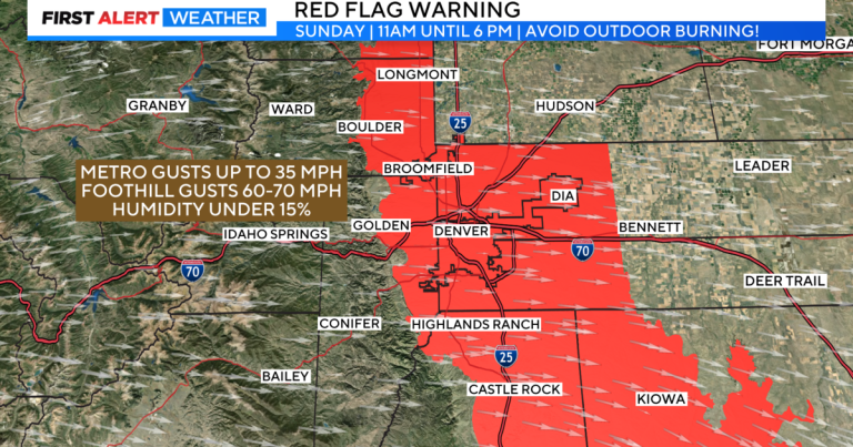
With winds expected to reach 35 mph in the Denver metro area and 60 to 70 mph in the Front Foothills, a red flag warning has been posted from 9 a.m. Sunday until midnight for the Denver metro area and the southbound I-25 corridor. . to Trinidad and includes much of the plains of Colorado. Fire danger will remain high through Monday with stronger wind gusts of up to 55 mph in the Denver metro area.
CBS
The mountains will be dry and windy on Sunday with a cooler change starting Monday into Tuesday. This next system will provide heavy snow in the mountains along with some accumulating snow in Denver on Tuesday of next week.
There is a winter storm watch in the northern and western mountains of the state. Some locations could see up to 2 feet of snow by Tuesday night. With significant travel impacts consisting of snowfall and snowfall. Wind gusts could reach 50 to 65 mph for the northern and central mountains. In the southwest mountains, some winds could reach about 70 to 80 mph.
A cold front will bring cooler temperatures to the Denver metro area Tuesday into early Wednesday morning. At this point, it appears that amounts may be in the 1 to 3 inch range. This may change as we get closer to Monday.

