Eric Green weather February 21
Riding today's strong wind event brings a warmer weekend
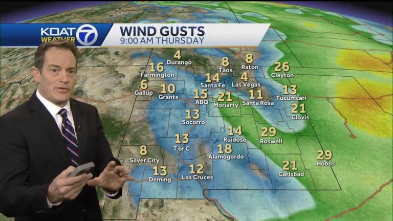
Even to this day, the weather will change. It's an impressive weather day. Yes, we're going to need some wind, and some glass cleaner for all those camera lenses by the end of the day because they're going to be throwing up a lot of dust. We have a view from the northwest corner of Albuquerque now. Strong wind event today. Still expected. A calming of the nerves follows, but it is only brief. We will be back this weekend. Next week is another storm system bringing more strong winds. We think there might be a better chance in rain and snow. Moderate temperatures continue. today. Note that we're back in the 60s and 70s for most of the state, and we're looking at just a slight chance at some scattered showers, a wintry mix, and snowfall on the higher terrain in northwest New Mexico. In the Four Corners area where we're completely dry today for the southeast-central part of the state, the winds will blow right through, pick up late in the morning, and probably peak around 2 p.m. and all of these brown shaded areas in southern New Mexico, especially On higher terrain, it is where the strongest winds blow. Can be harmful in the 60 to 70 degree range Winds relax strongly this evening, starting around dinnertime and after the sun really rises. Six o'clock, 7:00, is the time when the wind strength decreases significantly. Blue shaded areas with afternoon and evening wind warnings up to 55. High wind warnings Sacramento Mountains and down here in Eddy County where on the Guadalupe Mountains, we believe the potential for wind gusts could be in the 90 mph range. Very dry with moderate temperatures. And once those winds pick up, the fire danger is extreme in Albuquerque and basically all points south and east except for the Sacramento Mountains, where we still have some good snow in spots, there overnight, as the winds settle into a cool place in the air above freezing in Albuquerque. But we've reached below freezing in the 20s for western and northern New Mexico, so Thursday will likely be the coolest day of the week at that time. There are still a few above average 50 and 60 degrees. Little cloud cover. And tomorrow, you know we don't fully recover from the wind, but our forecast wind gusts you can see through the central part of the state, just 20 to 25 miles per hour. So, it's a good comparison to what we're going through today. Right now in northwest New Mexico, the four corners or the only corner of the state where we have a slight chance of scattered rain and a little mountain snow on Thursday and Friday highs in the mid 50s and upper 50s Saturday and low 60s Sunday. Here's the next storm system with calm Monday through Tuesday and a likely better chance of some rain and snow with strong winds possible. Southwest New Mexico has some strong winds today. Highs are 60 to about 70 degrees. We're not really getting any colder on Thursday-Friday, and we actually look warmer on Saturday-Sunday. In anticipation of the next storm, which will witness a lull in the rain and the possibility of snow falling on the mountains. Again, there may be very strong winds. Here is southeastern New Mexico. We are warm today, 70 to about 80 degrees which is the highest we have come close to setting. We have strong winds hitting the windiest area of the state today. Here we are concerned about wind damage and some power outages. We'll be back in the 60s on Thursday and Friday and back in the 70s and 80s this weekend. And then it looks like there will be strong winds for at least two days early next week. Rain and snow chances don't look great for us in the east here. Uh, here in northeastern New Mexico, a windy day for sure. Mild, two spikes at around age 60 or under age 60. We're getting to the 50s. This is still true. About average for Thursday and Friday before we get back into the 60s. This weekend and then get windy again next week. Central northern mountains. Highs will be in the 50s in Taos and Los Alamos and around 60 in Santa Fe and Espanola Valley. A windy day, but we're not the windiest part of the state. Rain and snow chances are basically Diya's way today. Under 50, Thursday, Friday, Top 50, Saturday. Back to above 60 here in Santa Fe on Monday before the next storm for the Albuquerque metro. Well, we'd love for these temperatures to be every bit as mild as they were yesterday. Close to 70 at our afternoon highs. Running about ten degrees above average but strong afternoon wind gusts will keep you from enjoying the day. This won't be a day for outdoor activities as dust and pollen are in the air with just a breeze tomorrow and a slight drop in temperature to the 60s Friday afternoon. And look at these numbers for the weekend. About 65 to 70 degrees. And then we
Eric Green weather February 21
Riding today's strong wind event brings a warmer weekend


