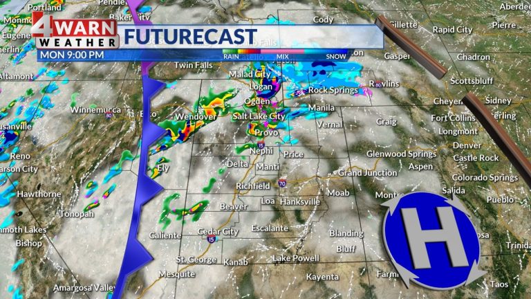
salt lake city (ABC4) – Happy President's Day, Utah! After a fairly calm start to the day, we will see steady changes as the day goes on. This is thanks to a large storm system off the Pacific Coast that will be sending energy and moisture our way over the next few days.
During the afternoon, clouds will increase along and west of the I-15 corridor with daytime highs reaching the 40s and 50s for most. In southern Utah, there will be a few spots that reach the low and mid 60s! By late this afternoon and into tonight, the potential for wet weather will begin to increase, primarily centered on northern Utah although some rain cannot be completely ruled out further south.
Rain will continue to spread across northern Utah tonight and may come in waves. By tomorrow, rain will become more widespread resulting in the potential for scattered showers across the state. Due to our southwesterly flow, temperatures will remain above seasonal averages, meaning most of what we will see will be valley rain and mountain snow with snow levels remaining above 6,000 feet through tomorrow. Scattered showers will continue into Wednesday, but as temperatures get a little closer to seasonal averages, we will start to see snow levels drop a bit.
With more mountain snow expected, the National Weather Service has already posted winter weather advisories for our northern mountains including the Wasatch and western Uintas. These warnings will begin at 5pm today and continue until 4am Wednesday for the Wasatch Mountains north of I-80, but for the southern Wasatch and Uintas, the warnings continue until 10pm Wednesday. During the duration of the warning, the Northern Wasatch State could receive a half foot or more of snow while the Southern Wasatch and Uintas could receive between 1-2 feet of snow.
When it comes to totals through tomorrow night, the upper cottonwoods and Western Uintas could rise a foot or two, with a few pockets potentially increasing a bit more. The northern mountains as a whole will likely see between 5-10 inches with a foot and a half possible in local areas. The central and southern mountains will likely see several additional inches. Benches and valleys will see mainly precipitation, however, cooler valleys and benches could see minor accumulations of an inch or two. Mountain valleys will see a 3-inch impact due to the high snow levels this time of year. In Park City, where the elevation is a little higher, there is a better chance of snow accumulation which could result in 2-6 inches.
By Thursday, our storm system will begin to taper off, but it looks like some rain will still be possible with temperatures that will be a little closer to seasonal norms. Calm conditions settle in at the end of the work week and beginning of the weekend before more active weather arrives next week. Stay tuned!

