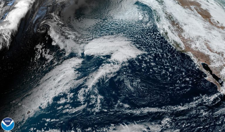
Forecasters warned that up to 37 million people were at risk of potentially life-threatening flooding in California overnight and into Sunday, as an “atmospheric river” brought heavy rain, snow and strong winds with the possibility of downed trees and power lines across the state. .
The National Weather Service in the Bay Area warned of “widespread” damage to trees and power lines throughout Monterey County, impassable roads and power outages, with wind gusts of up to 75 mph expected.
In San Jose, a community of unhoused people living along the Guadalupe River was ordered to evacuate to community centers as the river was expected to swell due to heavy rains in the Santa Cruz Mountains, causing risks to life and property, the city said. San Jose. San Jose said in public emergency updates.
The storm marks the second time this week that the state has been hit by an “atmospheric river” — plumes of moisture traveling hundreds of miles across the Pacific Ocean. Weather rivers dumped heavy rain in the Bay Area on Wednesday, halting cable car services, before moving to Los Angeles and San Diego by Thursday.
Officials in Santa Barbara County raised evacuation warnings to orders on Saturday, calling on residents to be in a “very high state of preparedness.”
Sheriff's deputies and search and rescue teams ran house-to-house evacuation notices to evacuate residents, as beaches across the county were closed indefinitely.
Gloria Sandoval, a spokeswoman for California State Parks, warned the public to “stay out of the ocean during storms and respect temporary closures” as surf spots like the popular Old Man's at San Onofre Surf Beach remained closed to access after January's storms. Heavy rain and severe weather have eroded the road in the lower San Onofre parking lot, and photos on social media showed parts of the beach parking lot below collapsing.
Serious flooding is possible across the state through Tuesday, with 12 inches or more of rain possible from the lower reaches of the Central Coast to the Los Angeles County coast, forecasters said.
If the upper ends of these estimates are reached, they could break rainfall records for the date and even monthly rainfall records, according to NBC News forecasters.
Flood watches, which are issued when conditions are conducive to flooding, will cover the coast in Sonoma, Marin, San Francisco, Monterey and San Luis Obispo counties, and all of the Southern California coast. Some hours begin late Saturday afternoon and continue through at least the end of the weekend.
Sunday's update from the National Weather Service's National Weather Prediction Center forecast a risk of rainfall exceeding flash flood guidance across large swaths of the state, with a “substantial risk” — estimated at 70% probability — in San Diego and Orange counties.
Gov. Gavin Newsom's office said Saturday that eight thousand three hundred state workers were prepared to respond to emergencies and damage related to the storm. More than 20 teams of search and rescue personnel were deployed to highway and urban waters up and down the state.
The storm comes as the San Diego County Medical Examiner's Office announced it was investigating three deaths in late January in connection with California's latest encounter with severe storms.
Jan. 22 was the wettest January day on record in San Diego, which saw rare and devastating flooding in urban neighborhoods far from the coast, unusual for the dry southwestern corner of the state.
Atmospheric rivers cause more than $1.1 billion in annual flood damage on average, according to a 2022 study in the journal Scientific Reports.
Climate change increases the strength of storms, as a warmer atmosphere can absorb more water vapor, giving storms the ability to produce more intense rainfall. Off the coast, rising sea levels due to global warming are increasing the size of waves, accelerating erosion rates and contributing to higher California tides.

