

- El Niño has officially intensified into a powerful event.
- The El Niño phenomenon is likely to continue through the spring.
- El Niño could affect weather conditions this winter, but it is only one factor.
A strong El Niño has now developed in the tropical Pacific Ocean, which could impact weather conditions in the United States and around the world, according to a November update from the National Oceanic and Atmospheric Administration (NOAA).
Here are the key takeaways from the November update:
1. “Above-average sea surface temperatures across the tropical Pacific indicate a strong El Niño, with increasing anomalies in the central and eastern and the central Pacific Ocean last month.”
This means that three-month average sea surface temperatures in a given region of the tropical Pacific Ocean were above a threshold of 2.7 degrees Fahrenheit warmer than average. The average for the last three months from August through October was slightly higher than that at 2.78 degrees.
2. NOAA says El Niño conditions of any strength are likely to persist through the spring. There is a 55% chance that persistent strong El Niño conditions will persist through the first three months of 2024.
3. There is also a 35% chance that El Niño will strengthen and become historically strong, or what is called a super El Niño, during the period from November to January. This means that sea surface temperatures will exceed the threshold of 3.6 degrees warmer than average. There have been three super El Niño winters since 1950 in 2015–16, 1997–98 and 1982–83.
Here's why this is important: El Niño is a periodic warming of a strip of water along the equator in the Pacific Ocean. You can see how this strip of ocean warmed dramatically from March to early November in the side-by-side comparison below.
The National Oceanic and Atmospheric Administration (NOAA) declares that El Niño has developed when sea surface temperatures in a particular region of the tropical Pacific Ocean reach at least 0.9 degrees above average for at least a month and are accompanied by changes in the atmosphere. This threshold for the current event was first reached in June.
El Niño can affect weather patterns thousands of miles away in the United States and around the world. Since most El Niños peak in late fall or winter, they can have their strongest impact in the colder months of the year. El Niño occurs approximately every two to seven years.

A side-by-side comparison shows how sea surface temperatures rose from March (left) to early November (right) in the equatorial Pacific. Blue shades show cooler than average water temperatures, and orange/red shades represent above average water temperatures.
(NOAA)
Here's how El Niño typically affects winter weather in the United States: In general, classic strong El Niño winters tend to be wetter than average across much of the southern United States, from parts of California to the Carolinas, partly due to the path of the stronger southern jet stream.
In much of the northern United States, stronger El Niños tend to produce warmer winters.
We've found that some cities in the Southwest, Southern Plains, and Mid-Atlantic experience their snowiest winters during El Niño.
(More: What could El Niño mean for snow this winter?)
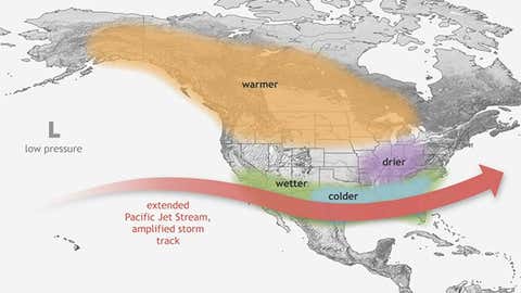
Typical impacts during El Niño from December through February in North America.
(NOAA)
However, El Niño is not the only driver that can affect winter weather: First, not all El Niños are exactly the same. Even a stronger El Niño does not necessarily guarantee strong effects on the weather pattern as shown in the map above.
The last two strong El Niños demonstrated this with very different results. For example, the winter of 2009-2010 was much colder than expected in the United States during a strong El Niño winter.
(More: The latest strong El Niño shows a variety of possible outcomes this winter)
Two wild cards that meteorologists are watching that could overcome the influence of El Niño for part of the winter are the polar vortex and the Greenland Blocking. But it is difficult to predict months in advance what impact these factors might have, if any.
MORE KIDS COVERAGE ON WEATHER.COM:
6 changes that the El Niño phenomenon may bring about compared to last winter
How did El Niño get its name?
What could El Niño mean for California?
Chris Dolce He has been a senior meteorologist at Weather.com for over 10 years after starting his career with The Weather Channel in the early 2000s.
The Weather Company's primary journalistic mission is to report on breaking weather news, the environment, and the importance of science in our lives. This story does not necessarily represent the position of our parent company, IBM.