WDSU Weather Alert Day
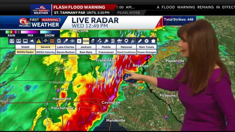
Here's a look at sports. Back to you all right. The time is 1248. And let's move on to the weather. now. We are on a weather alert, and severe weather of course poses a risk. WDSU Chief Meteorologist Margaret Orr is keeping us safe. What is the latest. So we have a severe thunderstorm warning in effect for the North Shore. The northeastern part of Washington Parish, just north of Bogalusa. Tornadoes may be possible. Definitely 60 mph winds. You'll be seeking safe shelter and then along that line, locally heavy rain and in fact, a flash flood warning in effect for the North Shore until 330. Here's a look at the first warning radar from WDSU. Let me show you the storm. And for anyone who really wants to know where the worst weather is, you can tell right away that you can look at the radar and you can see where there is the most lightning. Often this is the indicator. So, here, this is where it gets really dicey. Let's zoom in a little. Here's Angie, here's Varnado. This storm is moving to the northeast. Let me run a storm course for you. I am watching this carefully. So wait, let's pause it now. We're doing the storm track for this area of heavy rain moving northeast at about 35. It's moving toward Ford Creek. So now we just want to scroll down. Look, there's some pretty heavy rain in Folsom Covington above you right now. Madisonville as well. You have strong storms moving toward the lakes. Of course, you have special marine warnings. Laplace is very heavy towards Thibodaux. Now let's take a look at those predictions. So here's a look. Weather alert days today and tomorrow. Flash flooding is likely especially as it relates to the north shore concerns of those rivers on the north coast which could produce some strong storm surge. The front does not move. that's the problem. It will continue and put us at risk for locally heavy rain, not just today and today. It's mainly the North Shore, but we'll see it tomorrow on the South Shore. Red indicates where we have flash flood warnings, and green indicates where those rivers will rise. 72 degrees. Now the south wind is at 13 o'clock. How much rain? Here's a look at our latest forecast model for tonight. It says 2 to 5 inches. We've already had 2 to 4 on the North Shore. This lets you know that this rain is actually being produced. Then you go to South Friday Beach. We see about two and a half. Let's take a look at the timing. So, the problem this evening is that the rain isn't moving away from the North Shore. We are continuing to rain until about 9:30. Well let's start. Go to the morning all night. Doesn't look too bad. And then the rain comes to the south shore. on. Ten to one to 2. We are in danger of locally heavy rain. So, check out WDSU's first weather warning. We have weather alert days. The next two days. On Saturday, a cold frontal movement
WDSU Weather Alert Day
Flash flood warnings have been posted this afternoon for the Northshore. 2-4 inches of rain has fallen, and more will fall. Concerns about rising Northshore River. Monitor the situation. Keep cars parked high. Flash Flood Warning for River Parishes in Bayou Parishes. 2-3 inches of rain has fallen, and more will fall. Flash floods happen. There is a risk of severe storms. A severe thunderstorm warning has been posted for parts of Washington Parish. There is a risk of strong storms along the squall line. Strong gusty winds and an isolated tornado are possible. Stay aware of the weather. Today it looks like heavy rain will be on the North Shore. Heavy rain is expected on the south coast late Thursday morning and into the afternoon. More rain is possible on Friday, and more rain is possible on Saturday morning. Then the weather clears. It looks good Sunday through Monday.
Flash flood warnings have been posted this afternoon for the Northshore. 2-4 inches of rain has fallen, and more will fall. Concerns about rising Northshore River. Monitor the situation. Keep cars parked high. Flash Flood Warning for River Parishes in Bayou Parishes. 2-3 inches of rain has fallen, and more will fall. Flash floods happen. There is a risk of severe storms. A severe thunderstorm warning has been posted for parts of Washington Parish. There is a risk of strong storms along the squall line. Strong gusty winds and an isolated tornado are possible. Stay aware of the weather. Today it looks like heavy rain will be on the North Shore. Heavy rain is expected on the south coast late Thursday morning and into the afternoon. More rain is possible on Friday, and more rain is possible on Saturday morning. Then the weather clears. It looks good Sunday through Monday.


