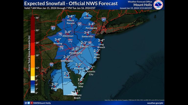
The latest snow total forecast for the National Weather Service's Mount Holly, New Jersey area.
A coastal storm set to impact eastern Pennsylvania is no longer a major hit, but will still be felt by leaving several inches of snow behind.
The National Weather Service's Winter Weather Advisory is in effect for the entire area from 7pm Monday until 1pm Tuesday. The warning warned that the snow would lead to slippery conditions on the road, and possibly even a risky morning commute.
Snowfall forecasts from the Weather Service's Mount Holly, N.J., forecast office show 3 to 4 inches of snow across much of the area.
Snow will likely begin Monday night, earlier than initially expected, and continue into Tuesday as a low pressure system passes off the coast.
Areas to the north and west, including Berks, Chester and Montgomery counties, are expected to receive the most snow from the storm, and accumulations of more than 4 inches are possible in some local areas, according to the weather service.
Expect “continuing light, persistent snowfall across the Lehigh Valley and Poconos,” the weather service’s forecast discussion notes. Areas to the south and east will be in the 2-3 inch range due to potential dry air mixing, according to forecast discussion.
If forecasts are correct, this could mark the end of the snow drought in Philadelphia, which has not seen significant snowfall in nearly two years. The last snowfall measured at Philadelphia International Airport was on January 29, 2022, when 7.5 inches fell.
The storm is no longer expected to rapidly intensify, which would have resulted in higher snowfall totals. The forecast discussion notes that “there are still some questions about how close the low is approaching,” which could further impact snowfall totals.
The system will pass out to sea by Tuesday night, with any rain quickly pushed away, according to a forecast discussion.
While the area will be spared a major snow event with this storm, another system is expected to move in Thursday night into Friday.
There is still a lot of uncertainty in the forecast for that storm, but “there is a good chance of another widespread, possibly relatively large, snowfall,” the forecast discussion notes.
However, the presence of cold Arctic air moving into the region makes it likely that any precipitation will fall as snow. High temperatures throughout the week will have a hard time getting above freezing. The temperature on Wednesday is expected to reach only 25 degrees.
After the storm Thursday night into Friday, a cooler air mass is expected to move in Saturday, with highs again in the 20s, according to forecast discussion.

