The potential for severe weather is diminishing but not gone
Although the main threat is subsiding, we continue to track more severe weather conditions
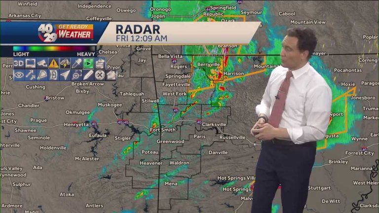
Uh, back here guys, we're continuing on track, uh, some storms in the area. Things are starting to go downhill, though. It appears that storms that moved across northwest Arkansas earlier, at least through Benton and Washington counties, are now in Carroll and actually coming into Newton and Boone counties. Pretty much completely out of the area at this point. We have other storms trying to develop to the southeast of that. We'll have to watch this activity. But the expectation now is that we're not going to get a significant amount of additional severe weather of any form along this border that we have here. We may see a severe thunderstorm here or there, but we don't expect much. Overall, we're kind of thinking right now that things are kind of up in the air. They are definitely heading towards northwest Arkansas. No additional severe weather is forecast for Northwest Arkansas. Very good news over there, in the river. But even let me remove this caveat here. Even in the river valley, where we still have that back boundary, there's not a lot of potential for new severe weather. There is certainly more than that in Northwest Arkansas. but. So it's not zero, but it's low. It's low now to the south, and even beyond these limits, we have a tornado warning here for central Arkansas outside of our area. There were multiple tornado warnings around the Little Rock area tonight. Well, that border runs all the way from here to Paris, Texas. And so that boundary, along which you might get a little bit of activity just north of it, um, this one will probably be more active and at least some rain will extend from it and into perhaps the far southeast. Le Flore County, southeastern Scott County, and certainly Polk County. But for the most part, our region stays south of that border. This generally has greater potential for severe weather, and new severe weather that must be developed. These are the limits. This is the most worrying thing. this. Oh, there will be more rain and intermittent storms. You can see new storms trying to develop here, but they're not really intensifying quickly. There is nothing dangerous here. Maybe a little isolated. Small hail, gusty winds, and a little lightning at times. But, uh, the bulk of the serious threat, I think the rest of the night will be along this border that extends from Little Rock in northeast Texas. We'll be watching it closely though. Once again, as we head into tomorrow morning, as we've been telling you all day, the odds of wintry weather in the morning have dropped dramatically. We started telling you about it this morning on social media. We told everyone about it on the 5 and 6 o'clock news, and after that, we reduced the snowfall total by nine. And ten. Now this is no longer a harsh day for us. So it won't have much effect. Winter weather wise in northwest arkansas river valley. Tomorrow morning there will likely be some flurries and snow showers making their way. You know, you might see dust here or there. Uh, temperatures will drop below freezing quickly. It's going to be very cold and windy, you know, there might be some icy patches forming, but overall, travel really shouldn't be that difficult. So. Well, that's kind of good news for Friday. Now, come Sunday, that's a whole different story. Um, I don't see this person just going away or dying. Well, this will continue to be something that we'll monitor and provide more information on as we get into Friday and into Saturday, as we start to get more information, new information on it, we'll continue to update you on that. This person will have a real impact. Ah, only Sunday to Monday. In the meantime, we'll keep watching things. So keep it set here until 40/29.
The potential for severe weather is diminishing but not gone
Although the main threat is subsiding, we continue to track more severe weather conditions
The probability of new severe weather is decreasing but the threat has not gone away. Storms that moved through northwest Arkansas earlier nearly exited the area. There is a system in the river valley that can cause severe thunderstorms. There were several tornado warnings in central Arkansas, near Hot Springs and Little Rock. The impact of winter weather is decreasing in our area as well. We can still see dust and flurries around the area. We are also looking forward to cool temperatures and strong winds. Watch the forecast in the player above.
The probability of new severe weather is decreasing but the threat has not gone away. Storms that moved through northwest Arkansas earlier nearly exited the area.
There is a system in the river valley that can cause severe thunderstorms.
There were several tornado warnings in central Arkansas, near Hot Springs and Little Rock.
The impact of winter weather is decreasing in our area as well. We can still see dust and flurries around the area. We are also looking at cool temperatures and strong winds.
Watch the forecast in the player above.


