Strong winds and severe storms possible Friday in South Carolina: Here's the latest timing
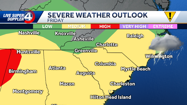
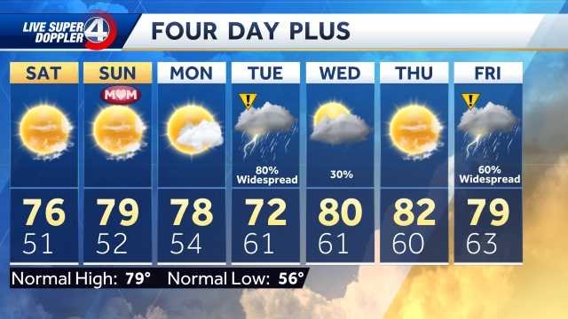
happy Friday everyone. We have a wind advisory in effect for much of our viewing area until early tomorrow morning. These winds will blow at times as we expect more rain and some isolated thunderstorms today. Here's a look. 1230 this afternoon, 30 to 35 mph. This will be the average. But when you look carefully and closer here, you can see that some of us will experience higher wind gusts of up to 40-45 mph. This is completely possible. Here's 730 tonight. Look at that. Nearly 40 mph winds were blowing in Greenwood and Lawrence overnight. By the way, our winds will be blowing hard. So overnight you might hear some of these winds. Here's a look at 530 tomorrow morning. Some of those gusts were 40-43 mph across the upstate area and about the same in the mountains at times. Fortunately, these winds will calm down heading into tomorrow evening. So Sunday should be sunny and cool, but not dealing with all that wind outside. Now we have clear skies. This is great news. This means that temperatures will drop. Dew points will decrease. This is the moisture in the atmosphere. This is essentially stable air. There is very wonderful news in the West. We have some rain coming our way and some isolated thunderstorms. We have an area of low pressure bringing a cold front along with it. Behind that cold front. This will be the cooler air heading into Saturday and Sunday and extending into next week. Of course, we have some rain and a chance for some isolated storms. All are yellow, a moderate threat, and some of those thunderstorms could become severe. This is an improvement from yesterday. Yesterday, most of these areas were at a higher threat level. So these nice, dry, stable mornings are actually helping us out somewhat without all those clouds. We're losing some of that heat. We lose some of that instability. So, good news again, but we still want to stay tuned to today's weather due to a look at Anderson Greenwood in Abbeville. Elberton. You are still at moderate risk that some of these thunderstorms could become severe and the main concern will be strong winds within some of these thunderstorms. So let's take a look at the timing. It will be dry most of this morning as we reach 1 and 3:00. That's when I think a lot of this rain will start moving in with at least some heavy rain amounts. These are heavy rains and isolated thunderstorms. Here at 3:00 this afternoon. You can see that it will be widespread while you are back home. 430 5:00 We'll still be dealing with some of those showers, some isolated heavy rains and some of those isolated storms as well. The cold front itself, there through Gaffney, Spartanburg, Lawrence, and it looks like Greenwood will cross the area by 637, 730 tonight, somewhere in that time frame. There must be some kind of hit. After that, temperatures will drop and we are looking at a cold air mass that will move in for the rest of the weekend, but it will be dry. So Saturday and Sunday will be absolutely fantastic. But on the cold side, Monday night, MLK Day, we have a chance for some snow in the mountains. We wouldn't be surprised if we didn't have a couple of planes flying around parts of Upstate, but that's still a small chance. Again, it won't be much. If anything, head to early Tuesday morning. We will continue some of these fluctuations in parts of the mountains. But otherwise dry. And frankly, early to mid-next week, temperatures will be very cold, especially at night. Today is a 53 degree impact day, isolated thunderstorms, gusty conditions and winds will continue throughout tomorrow, settling into 51 Sunday night. We have some isolated rain chances Monday night into early Tuesday in the UPSTATE. This will be about it. But overnight it drops to 18 degrees. Wednesday morning in the Upstate, it drops to 11 degrees
Strong winds and severe storms possible Friday in South Carolina: Here's the latest timing
Severe weather is likely in parts of South Carolina on Friday. Friday's system could bring 1-2 inches of rain, as well as some strong to severe storms. Check the interactive radar hereFor active alerts, warnings and monitoring in your area, click here. Watch live sky cams from across the Carolinas here Get extended and hour-by-hour forecasts here Strong winds are the main concern. Potential severe weather timing is 2 to 7 p.m. Many areas upstate fall into the moderate category for severe weather. There is also concern about some flooding due to Tuesday's heavy rainfall. We dry out in time for the weekend and cool off. LIVE RADAR BELOW: The cold air will stay with us through much of next week, with another chance of rain upstate Monday night into Tuesday and a chance of snow in the mountains early Tuesday morning. Temperatures Thursday and Friday will be in the 50s upstate, then drop into the 40s over the weekend. Temperatures in the mountains will be in the 50s on Thursday, then cool into the 40s on Friday and the weekend.
Severe weather is likely in parts of South Carolina on Friday.
Friday's system could bring 1-2 inches of rain, as well as some strong to severe storms.
- Check out the interactive radar here
- For active alerts, warnings and monitoring in your area, click here.
- Watch live Skycams from around the Carolinas here
- Get your hour-by-hour forecasts and extended forecasts here
Strong winds are the main concern.
The timing of possible weather fluctuations is from 2 to 7 p.m
Many areas of the Upstate fall into the average category for severe weather.
There is also concern about some flooding due to Tuesday's heavy rainfall.
We dry out in time for the weekend and cool off.
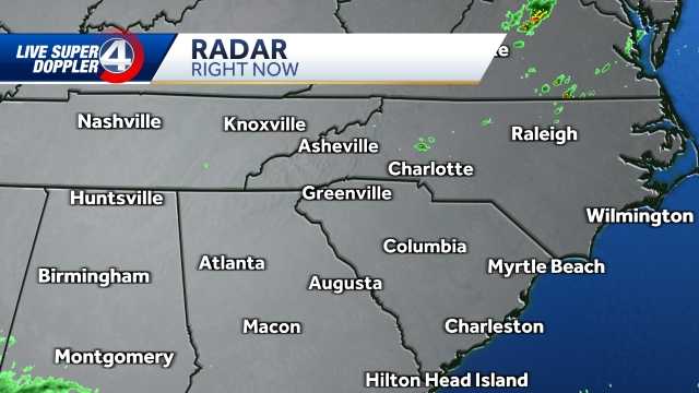
Live radar below:
The cold air will stay with us through much of next week, with another chance of rain upstate Monday night into Tuesday and a chance of snow in the mountains early Tuesday morning.
Temperatures Thursday and Friday will be in the 50s upstate, then drop into the 40s over the weekend.
Temperatures in the mountains will be in the 50s on Thursday, then cool into the 40s on Friday and the weekend.


