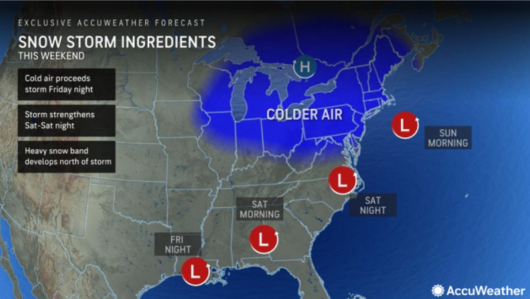
With a potential winter storm approaching this weekend, the big question many New Jerseyans are asking is: How much snow will we get?
The short answer: It's too early to tell. Realistically, New Jersey could get anything from no snow at all to a mix of rain and snow, or as much as 6 to 12 inches of snow, according to forecasters who continue to monitor the latest computer guidance models and atmospheric patterns.
The National Weather Service says the latest trend among major guidance models is toward more rain and less snow across much of the Garden State. That's because the storm — expected to make its way from the Gulf of Mexico on Saturday and intensify early Sunday — may hug the Atlantic coast.
If the storm takes that path, forecasters say, warmer air from the south and from the ocean will make its way inland, and cooler air will remain confined farther west.
On the other hand, if the storm takes an offshore track, the cold air will move east, boosting the chances of more snow in the central and eastern parts of New Jersey.
Forecasters say they won't be able to get a good handle on the storm's likely path until later this week, so any forecast of early snow is unreliable. In essence, any snow maps or snow numbers that appear on your social media feeds are wild guesses until a storm develops and approaches our area.
Currently, the National Weather Service's main office in New Jersey is holding off on issuing any snow forecasts for this storm. The same strategy is followed by the New York Regional Weather Service's office, which handles forecasts for the New York metro area, including five counties in northeastern New Jersey.
“It is too early to have specific details about the exact track, possible types of precipitation, and amounts of rain and wind,” the New York Weather Service said Tuesday afternoon.
The agency's New Jersey office said the “best chance for significant snowfall accumulations” would be in inland northern New Jersey, along with the Lehigh Valley and Poconos in eastern Pennsylvania.
“Precipitation types along the I-95 corridor and points south and east are highly uncertain at this time and are highly dependent on where the low will follow,” the office said. “At the moment, the consensus is for more rain with the potential for some snow mixed in at times, but we will simply need to wait until we get closer to the weekend before we make anything more definitive.”
AccuWeather meteorologists agree it's too early to issue a snowfall forecast with high confidence early in the week, but they say there could be a wide area of 6 to 12 inches of snow along the I-95 corridor if temperatures hold Cold enough all night on Saturday. Sunday.
“AccuWeather meteorologists expect significant road and airport travel disruptions due to the storm in the Northeast due to a wide band of rain on the way this weekend,” the private weather company said Tuesday afternoon in a report on the storm on its website. “The expected timing of the storm may allow for better travel Friday night and Saturday morning, rather than Sunday.”
Effects of rain, wind and coastal flooding
Aside from the possibility of heavy snow in some areas of the state, New Jersey could also get 1 to 2 inches of rain if temperatures remain above the freezing mark when the storm arrives.
Additionally, the weather service says New Jersey could experience gusty winds of up to 20 to 30 mph in inland sections and gusts of up to 40 mph in coastal areas. “Additional precautions may be needed given recent heavy rains and wet ground,” the agency said Tuesday afternoon.
The weekend storm could also cause coastal flooding in any area along the Jersey Shore and Delaware Bay, the weather service said. “At this time, it is too early to determine which communities may experience the greatest impacts and magnitude of flooding, if any.”
Long wait for snow lovers
If it feels like it's been a long time since New Jersey has had a major snow storm, the situation was worse in many Eastern cities, including New York and Philadelphia.
New York City hasn't seen even an inch of snow on the ground since February 13, 2022, and Philadelphia hasn't seen an inch of snow since January 29, 2022, AccuWeather says.
The last widespread snowfall in New Jersey occurred on February 13, 2022, when weather monitoring stations in 17 counties reported snow totals of at least 1 inch, and 11 of those counties had 3 inches of snow in some areas, according to snow data from the University of Rutgers. . The highest snow totals from that storm — which occurred on Super Bowl Sunday — reached 5 inches in parts of Sussex and Warren counties.
On March 12, 2022, 13 New Jersey counties reported snowfall of an inch or more, but that was limited to the northern half of the state. Very little snow fell in South Jersey in that storm.
The last “major blizzard” in New Jersey, where 5 inches or more of snow was on the ground, occurred in late February 2023, but it only covered the far northern region of the state. In that storm, from February 27-28, 5 inches of snow was reported in parts of Bergen, Essex, Morris, Passaic and Sussex counties, and 10 towns reported 6 inches of snow.
The heaviest snow total from last February's storm was 7 inches, reported at Highland Lakes in Sussex County.
Current weather radar
Thank you for relying on us to provide local weather news you can trust. Please consider supporting NJ.com With voluntary subscription.
NJ Advance Media staff writer Jeff Goldman She contributed to this report.
Len Melisurgo can be reached at LMelisurgo@njadvancemedia.com or @LensReality On X.

